Identifikation und Inhalt |
| Ref. code: | PLAN L 2607.1 |
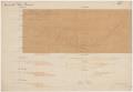
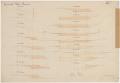
| Title: | Tösskorrektion, Grubbachdurchstich sowie Abgrabung unterhalb des Grubbachs; Querprofile und Situationsplan |
| Inhalt und Form: | Kilometer 5.849 bis 6.969.
Mit angeklebtem Transparentplan. |
| Creation date(s): | 3/20/1877 |
| Number: | 1 |
| Archival Material Types: | Plan/Karte |
| Ausprägung: | analog |
|
Planspezifische Merkmale |
| Authorship: | Aufnahme: Jeker |
| Preview: |
|
|
1
|
|
|
2
|
|
| Scale: | 1 : 1000, ca. 1 : 100 |
| Dimensions W x H (cm): | 70.0 x 48.5 |
| Technique: | Druck, Tinte, Grafitstift, Aquarell |
| Material: | Papier, Transparentpapier |
|
|
| |
Containers |
| Number: | 1 |
| |
Usage |
| End of term of protection: | 3/20/1897 |
| Permission required: | [Leer] |
| Physical Usability: | Eingeschränkt (Gebrauchskopie) |
| Accessibility: | [Leer] |
| |
URL for this unit of description |
| URL: |  https://suche.staatsarchiv.djiktzh.ch/detail.aspx?ID=1218867 https://suche.staatsarchiv.djiktzh.ch/detail.aspx?ID=1218867 |
| |
Social Media |
| Share | |
| |